Marathon Map
The roads that we run for the New River Marathon course have been rebuilt after Hurricane Helene. In 2026 we will return to our normal Marathon course, which is posted below.
Click on the map image below to view the interactive course map. Once you are viewing the interactive map:
-
To achieve a full screen view of the map, click on “Fullscreen” in the upper left of the map.
-
In the upper right corner of the map is a drop down menu with map viewing options…we prefer “Hybrid”.
-
You can highlight a section of the course to view a more detailed elevation chart of that section. To view a more detailed section:
-
Move your cursor along the x-axis (mileage) of the elevation graph. Mileage, elevation, and % grade will be displayed.
-
Click and hold a beginning point on the elevation graph. Drag your cursor and highlight the segment/distance that you wish to view in greater detail. When you release your mouse, the highlighted segment will be displayed.
-
To return to the full graph, single click the “de-select” button or single click the graph.
-
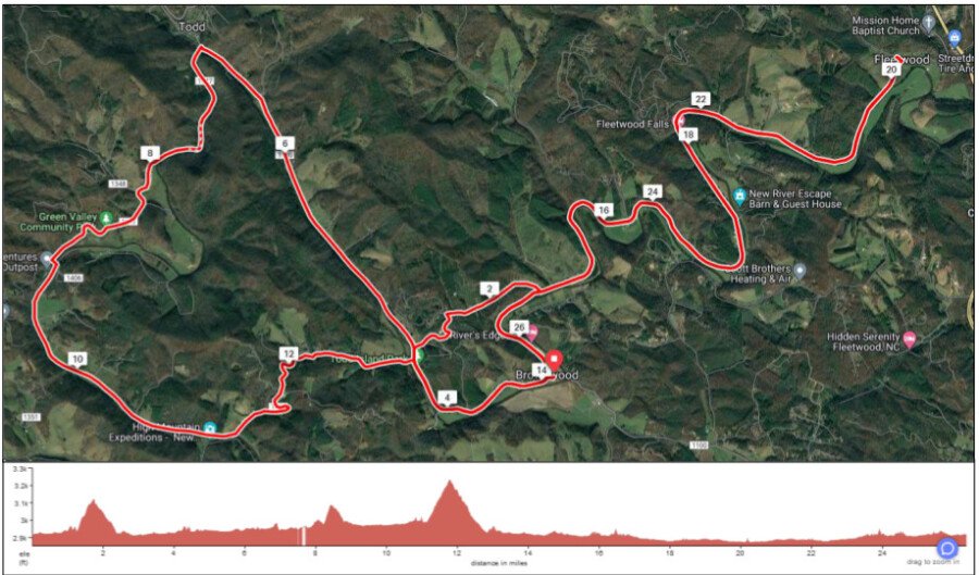
Marathon Course Notes: (USATF Certified: NC23014DF)
-
The Start and Finish Lines for Marathon are located on grass at the former site of the Riverside Restaurant, which was washed away during Hurricane Helene.
-
The course is predominantly paved with 2 dirt/gravel road sections:
-
The first gravel section (Mile 1.3 - 2.4) has a 0.45 mile uphill, followed by 0.65 downhill.
-
The second gravel section (Mile 7.5 - 7.7) is flat along the river on Big Hill Rd.
-
-
Race Flow:
-
Start - Mile 1.3: Flat and paved in the river valley.
-
Mile 1.3 - 1.7: Uphill on a packed gravel road.
-
Mile 1.7 - 2.4: Gradual downhill on a charming, packed gravel road…creek on one side, Christmas tree fields on the other.
-
Mile 2.4 - 6.9: Flat and paved in the river valley. Pass the Start/Finish at Mile 3.2.
-
Mile 6.9 - 7.9: Flat, paved section of Big Hill Rd in the river valley. Also includes 1/4 mile gravel section.
-
Mile 7.9 - 8.7: Changing gears as you run the "rolling" hills on Big Hill Rd. (+140 ft, -140 ft) However, you will not have the "pleasure" of the road's namesake. But you will have the pleasure of spectacular views of the river valley.
-
Mile 8.7 - 11.1: After descending on Big Hill Rd from Green Valley Community Park, you’re back in the scenic river valley on Big Hill and River Roads.
-
Mile 11.1 - 11.7: Climb to 3231 ft, the highest elevation on the course (+244 ft).
-
Mile 11.7 - 12.9: Enjoy the long recovery downhill as you drop back to the river valley (-287 ft).
-
Mile 12.9 - 20.1: Flat along the New River as you progress toward downtown Fleetwood (-83 ft). At mile 14.1 you will pass the start/finish.
-
Mile 20.1: U-Turn
-
Mile 20.1 - FINISH: Final stretch in the flat river valley to the FINISH!
-
-
Support Stations: approximately every 2 miles. Refer to the Race Day Logistics page for details.